Trinidad and Tobago Weather Center
39.0K subscribers
About Trinidad and Tobago Weather Center
Disseminating information on natural hazards for Trinidad and Tobago and Lesser Antilles. Submit reports, images & videos: https://wa.me/18684860510
Similar Channels

Natural Beauty Skin

Video

Xpose Limited

Marks Movies Video Editing

Club D Fans De Liam :pp

Weather Tv

الفيزياء المؤتمتة (بكالوريا) مع أ_قاسم الشيخ

La Página Bodeguera

Video Random

Status 💝 / Urdu Poetry / TV News / Shayari / Islamic Studio / Viral Video / Song / India / Khabar

IDS Information Office

IBDFAM
INEGI INFORMA

Digital Banner: Festival Poster & Video Maker App

Univer Vídeo
Swipe to see more
Posts
1:40 PM - South Oropouche River seen from Debe Trace. Live updates of flooded areas: https://ttweathercenter.com/2025/06/12/live-updates-another-round-of-rains-push-rivers-near-capacity/
1:30 PM - Flooding ongoing on Trantril Road, St. Augustine Live updates of flooded areas: https://ttweathercenter.com/2025/06/12/live-updates-another-round-of-rains-push-rivers-near-capacity/
1:50 PM - Flooding ongoing at Bisnathsingh Trace, south of the Caroni River in St. Helena. Avoid venturing into flood waters! Live updates of flooded areas: https://ttweathercenter.com/2025/06/12/live-updates-another-round-of-rains-push-rivers-near-capacity/
JUST IN @ 1:45 PM - The Caroni River is overflowing into Ibis Gardens, Caroni. Residents in the area should finalize preparations to protect lives, livelihoods and property as riverine flooding continues. 🎥: Andre Ramsahai Live updates of flooded areas: https://ttweathercenter.com/2025/06/12/live-updates-another-round-of-rains-push-rivers-near-capacity/
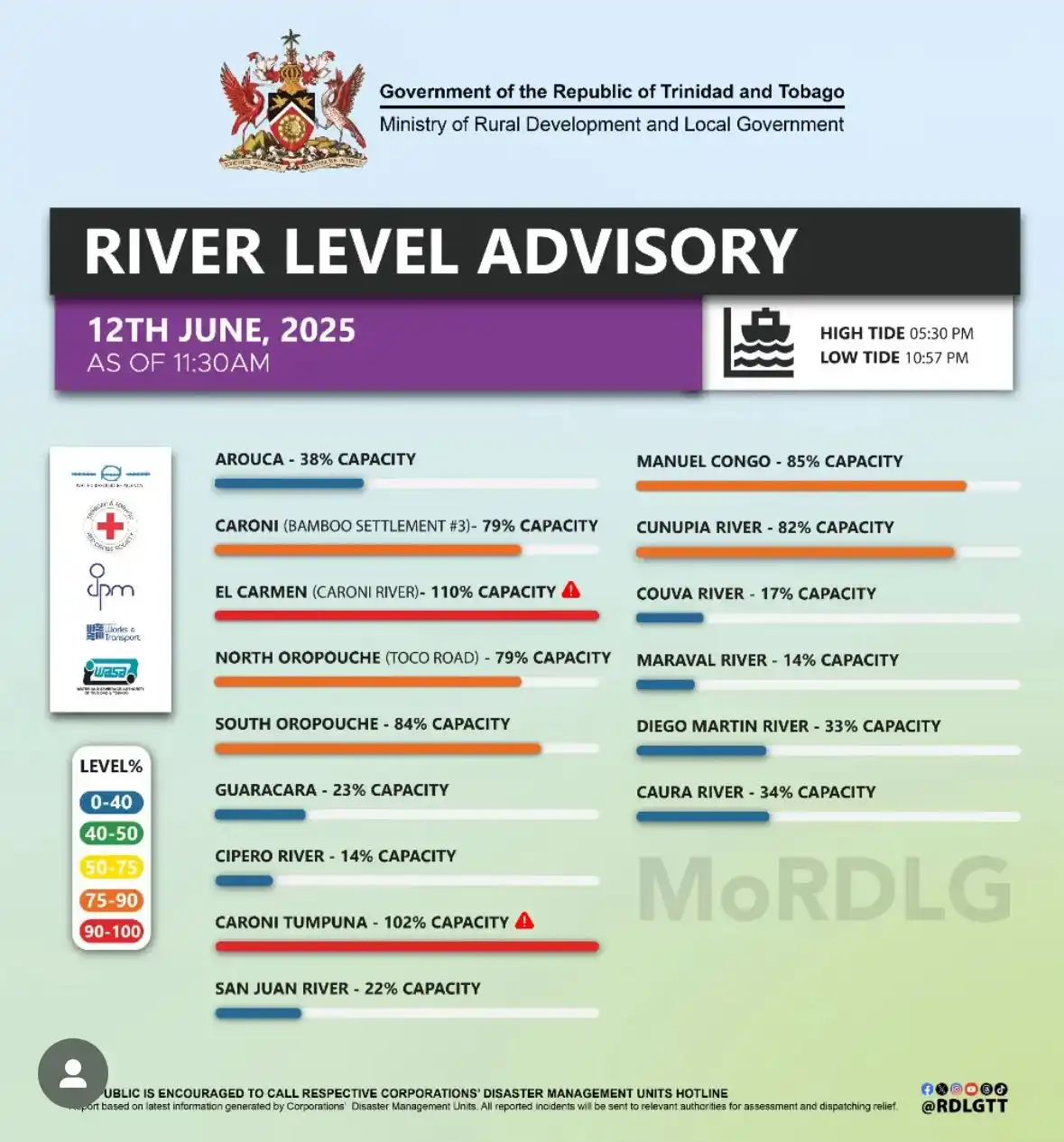
11:30 AM River Levels Across Trinidad The Caroni River continues to overtop at several points with other major rivers between 75% and 90% capacity. Smaller tributaries to these rivers are at or near threshold, flooding low-lying areas across south, central, and northern Trinidad. Additional ongoing rainfall, combined with further rainfall this afternoon through tomorrow and spring tides, are exacerbating flooding. https://ttweathercenter.com/2025/06/12/live-updates-rivers-overtop-as-more-rain-moves-in/
JUST IN @ 1:45 PM - The Caroni River is overflowing into Ibis Gardens, Caroni. Residents in the area should finalize preparations to protect lives, livelihoods and property as riverine flooding continues. Live updates of flooded areas: https://ttweathercenter.com/2025/06/12/live-updates-another-round-of-rains-push-rivers-near-capacity/
DO NOT VENTURE INTO FLOOD WATERS. 2:10 PM - A truck traveling on the Caroni Arena Road in the vicinity of El Carmen #4 is now stuck in flood waters. This is a developing situation. Live updates of flooded areas: https://ttweathercenter.com/2025/06/12/live-updates-another-round-of-rains-push-rivers-near-capacity/
2:00 PM - Heavy rainfall affecting parts of Trinidad, as seen from El Carmen #4, where riverine flooding is ongoing as the Caroni River overtops. Avoid venturing into flood waters! Live updates of flooded areas: https://ttweathercenter.com/2025/06/12/live-updates-another-round-of-rains-push-rivers-near-capacity/
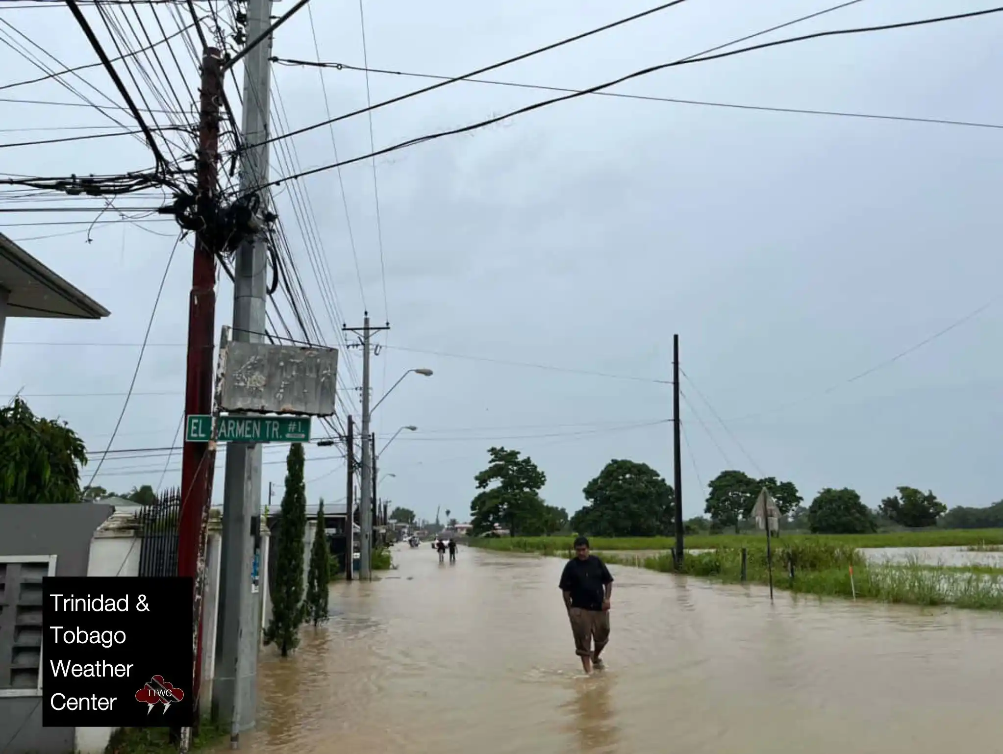
12:00 PM (noon) - Flooding between El Carmen Tr. # 1 and Santa Monica Tr, Caroni South Bank Road, El Carmen 🎥: Preity Ramsarran Live updates of flooded areas: https://ttweathercenter.com/2025/06/12/live-updates-another-round-of-rains-push-rivers-near-capacity/
11:30 AM - Flooding at the corner of the Caroni South Bank Road and El Carmen Trace #1 https://ttweathercenter.com/2025/06/12/live-updates-rivers-overtop-as-more-rain-moves-in/